by Emmanuel Kasongo Yakusu and Wannes Hubau
In this Congo Science Focus post, lead author Emmanuel Kasongo Yakusu (University of Kisangani, DRC / University of Ghent, Belgium) and co-author Wannes Hubau (University of Ghent, Belgium) present a study revealing evidence of climate change in the Congo Basin.
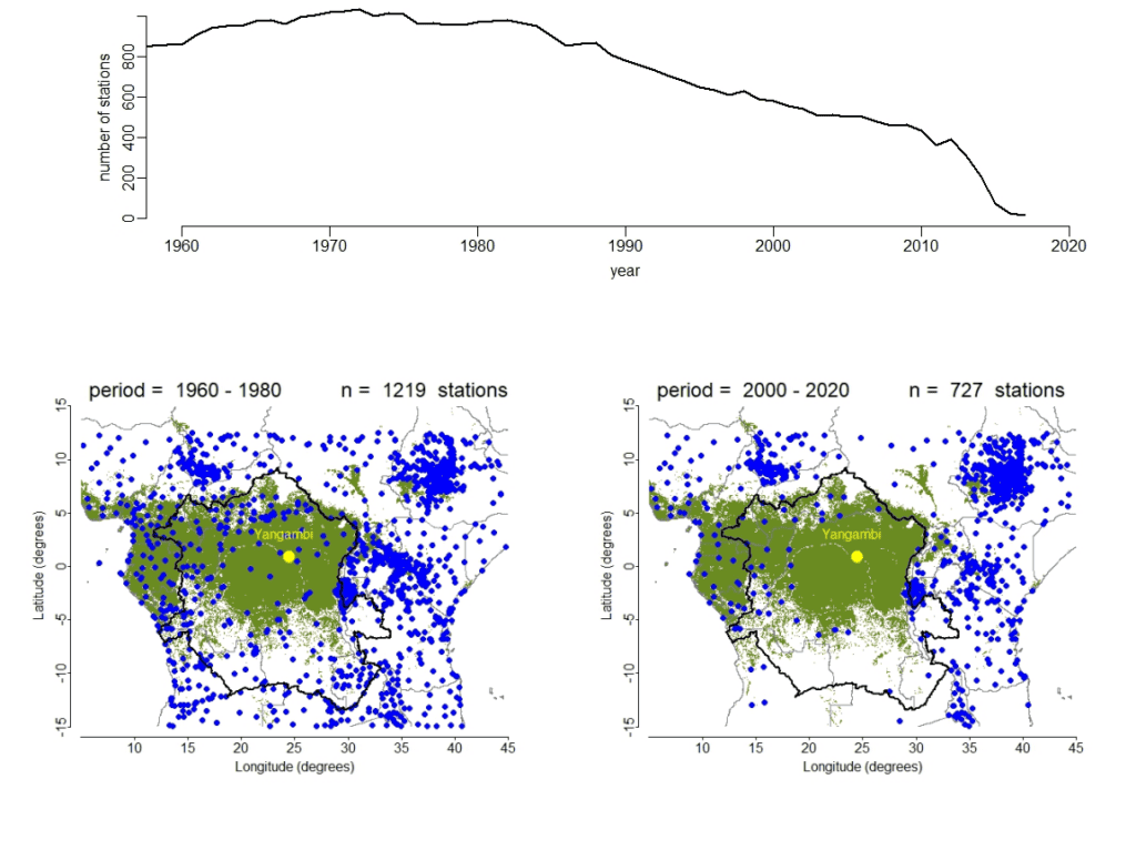
This multi-decade study published in Climatic Change in October 2023 presents the results of analyses of a unique digitised daily temperature and precipitation dataset covering the period 1960-2020 (61 years) from the Yangambi Biosphere Reserve. Yangambi is part of the UNESCO Man and Biosphere network and it is located in the heart of the Congo Basin, a region where ground-based data are not available for the last two decades (with a decline rate of ± 40%). In order to extend our results to the Congo Basin, we compared ground-based climate observations at Yangambi with monthly temperature and rainfall data generated by satellites.
Our results confirm a long-term increase in temperatures and temperature extremes since the 1960s, with strong upward trends since the early 1990s. We show a strong shift in precipitation patterns towards a more seasonal climate, with longer dry seasons and shorter but more intense rainy seasons since 2000. The change in precipitation patterns is accompanied by a strong warming trend, with a rapid increase in the frequency of hot days and nights and a decrease in the frequency of cool days and nights. This shift towards a warmer, more seasonal climate has major consequences for life in general (agriculture, agroforestry, water resources, health, etc.) and for the composition and functioning of forest ecosystems and biodiversity in the Congo Basin in particular.
These climate changes are already having a significant impact on crop yields in Yangambi. It is therefore vital for dynamic, climate-smart agricultural and agroforestry systems to be developed. There is also an urgent need for significant funding for climate research in the countries of the Congo Basin in order to better monitor climate change at local, national and regional levels, and thus improve policies and strategies for adapting to and mitigating climate change.

Figure: Evolution and geographic position of climate stations with available precipitation data in and around the Congo Basin (outlined in thick black line). The top panel represents the evolution of the number of stations with digitized climate data for the last six decades (1960–2020) (Nicholson et al. 2018). The two maps represent the geographic position of the stations with digitized climate data for two-decadal periods (1960–1980 and 2000–2020). Each blue dot in the maps represents a climate station; the yellow dot in the center of each map represents the Yangambi climate station (N 00° 49′ 12.4″; E 024° 27′ 22.6″). Green background color represents closed tropical rainforest cover following Global Landcover Map 2000 (Mayaux et al. 2003).
The full study: Ground-based climate data show evidence of warming and intensification of the seasonal rainfall cycle during the 1960-202 period in Yangambi, central Congo Basin is published in Climatic Change.
Radio feature (in French): RFI Afrique. La Science du bassin du Congo : une histoire qui reste à écrire (Épisode 2).
References:
Nicholson, S.E., Klotter, D., Dezfuli, A.K., Zhou, L. 2018. New rainfall datasets for the Congo basin and surrounding regions. J Hydrometeorol, 19:1379–1396.
Mayaux P, Massart M, Cutsem C Van, et al. 2003. A land cover map of Africa. European Commission, Joint Research Center 56p.
Title image shows devastation caused by flooding in the DRC over New Year 2024. Photo credit: Flood investigation team, DRC
Read more Congo Science Focus posts, highlighting important findings about the Congo Basin published in recent papers led by scientists from the region.