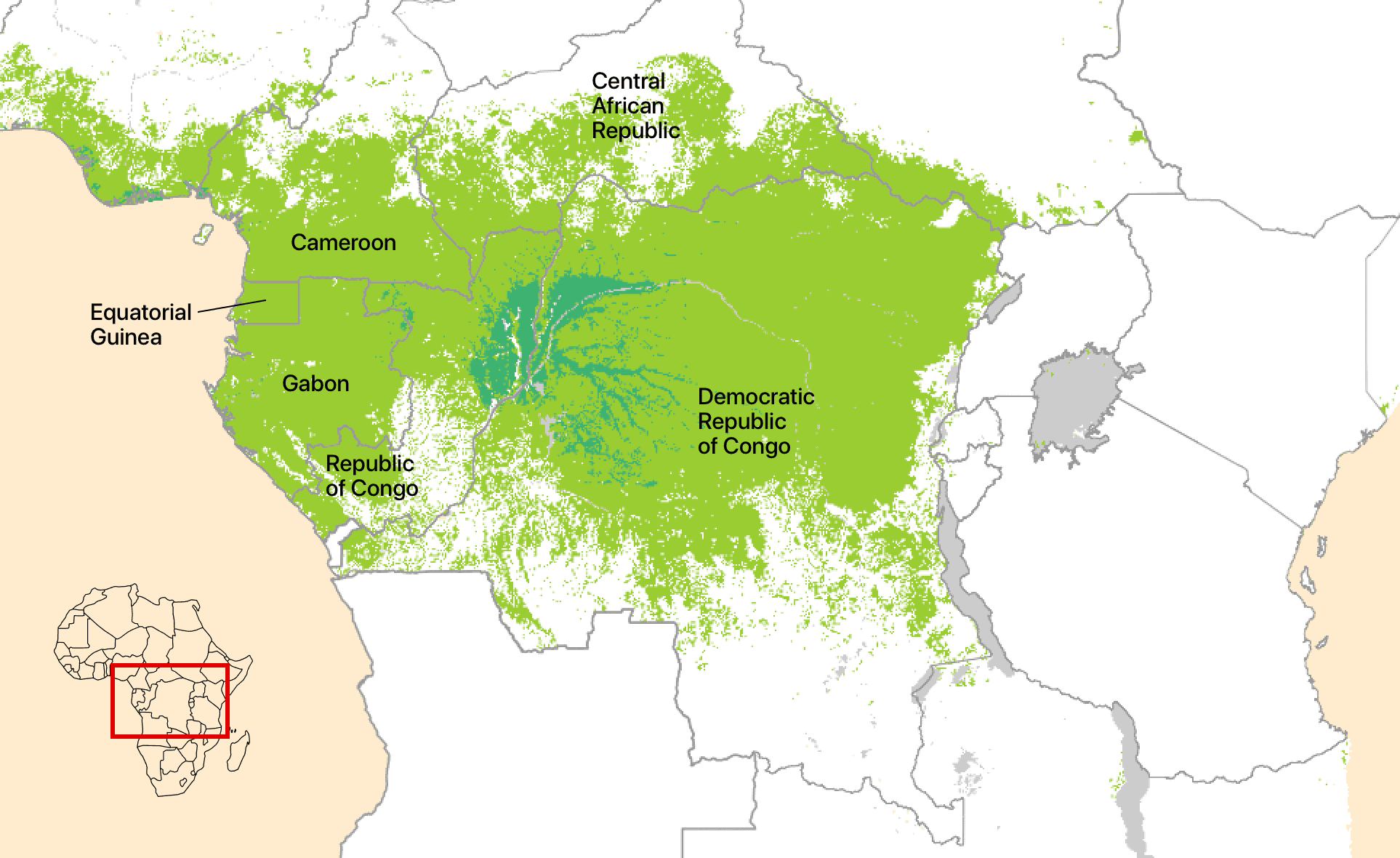
The Congo Basin and its contiguous forests represent the second largest tropical forest and river network on Earth.

The Congo River and its tributaries drain 3.68 million square kilometres, including much of the Democratic Republic of the Congo, and the Republic of the Congo, and parts of Cameroon, the Central African Republic, Rwanda, Burundi, Tanzania, Zambia and Angola.
The contiguous forests of the Congo Basin cover 2.4 million square kilometres, stretching across Gabon, Cameroon, Equatorial Guinea, and south eastern Nigeria in the west, to Democratic Republic of the Congo, Republic of the Congo and Central African Republic in the centre of the basin, and parts of South Sudan, Rwanda, Burundi, Uganda and Tanzania in the east.
The climate of the Congo Basin is hot and humid. The forests cool the climate so although it is on the equator, temperatures are lower than in areas to the north or south. There are two major rainy seasons, from March to May and September to November. Rainfall is dominated by deep convection – thunderstorms – with the Congo Basin having the highest lightning strike frequency on Earth. Total rainfall is typically over 1.5 metres a year, with greater rainfall closer to the Atlantic coast. The base of Mount Cameroon is one of the wettest places on Earth, receiving over 10 metres of rain annually.
While dominated by closed canopy tropical forests, other important ecosystems include the world’s largest tropical peat swamp forest complex, open forests and savannas. River and lake habitats are also important throughout the region. In the east, the Rwenzori mountains rise with montane, bamboo and even giant heather-dominated forests, and an Afro-alpine zone. In the west are coastal estuaries and mangroves, including 63 metre tall mangroves, the world’s tallest, in Gabon.
The ecosystems of the Congo Basin directly support the livelihoods of approximately 80 million local people, including benefits from agriculture, selective logging, collecting non-timber forest products and many other activities. The region’s major cities include Kinshasa and Kisangani (DRC), Douala and Yaoundé (Cameroon), and Libreville and Port-Gentil (Gabon), with smaller towns and villages across the region. There are approximately 900,000 autochthons (central African hunter-gatherers), from the Bamenga in the west, BaYaka more centrally, and the Mbuti and Twa in the east of the basin.
The total number of plant and animal species in the Congo Basin’s ecosystems, one aspect of its biodiversity, is unknown. The Congo Basin habitats are global centres of tree and mammal diversity, but many groups, particularly insects – which account for most species on Earth – have not been surveyed. However, we estimate that there are roughly one million species making their home in the Congo Basin, using three assumptions: there are 8.7 million species on Earth; over half of the world’s species live in tropical forests; and roughly one quarter of the world’s tropical forest is in the Congo Basin.
The Congo Basin forest provides many benefits to people far beyond the forested area. There is growing evidence that these forests generate rainfall that influences areas as far away as the Sahel and Ethiopian highlands, supporting a further 300 million rural Africans. Globally, the Congo Basin helps regulate the climate system, and African tropical forests absorb 1.5 billion tonnes of carbon dioxide annually, four percent of all the world’s fossil fuel emissions. They are also the world’s most efficient carbon-capturing ecosystem.
Viewed from the air or on a map, the Congo Basin appears to be uniform, but it is not. The type of trees found in the forest varies with climate. Those forests experiencing a cool and cloud-covered dry season, in the west in Gabon differ from the warmer forests in the north of the basin, and the forests that experience a less seasonal climate in the centre of the basin. The Congo Basin region is unlike the Amazon region, where differences in soils primarily determine which forest types occur.
Deforestation of primary forest is high in the Democratic Republic of the Congo, which has the second highest rate of deforestation in the world after Brazil. Each year DRC is losing about 500,000 hectares (a hectare is 100m x 100m). The primary causes are more people needing land to feed themselves and charcoal production, the dominant energy source in DRC. Deforestation is very low in Gabon and the Republic of the Congo, both classified as ‘High Forest, Low Deforestation’ countries.
It is very unclear what the future holds for the Congo Basin. The climate will get warmer, the population will be larger, and the population will be more urban, but there are few other certainties. Climate models, due to a lack of weather station and other data, do not agree whether the climate will get wetter or whether the dry seasons will intensify. Alarming new studies point to rising temperatures driving a decline in forest fruits, which is leading to elephants starving, and a newly identified tipping point in the central Congo peatlands which could release billions of tons of carbon dioxide to the atmosphere accelerating climate change.
Whether it is uncovering new values for the Congo Basin’s ecosystems, or discovering new vulnerabilities, science is needed to explain these to the world in order to make wise political choices.